
Archives: DSS Content
Regional Resilience Data and Analytics Service (RDAS)
—
by
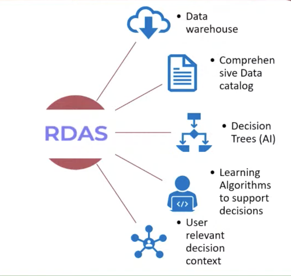
Regional Resilience Data and Analytics Service (RDAS) is developed by RIMES as a cloud-based, open-access platform for making available climate and sectoral data, and analytics capacities, for climate-informing policy, planning and investment decisions in the region, targeting to provide benefits for development institutions and their stakeholders, governments of inclusive countries, research institutions, and other relevant…
Forecast Customization System (FOCUS)
—
by
<!–td {border: 1px solid #cccccc;}br {mso-data-placement:same-cell;}–> RIMES developed the Forecast Customization System (FOCUS), with support from the UK MET under the ARCCC, intending to support the NHMSs in the region to access and generate customized seasonal forecasts using the inbuilt Multi-Model Ensemble (MME) methods. The tool also supports the validation and verification of the estimates. FOCUS…
Climate Risk Information System for Public Health (CRISH)
—
by
Climate Risk Information System for Public Health (CRISH) is a public health advisory system that is based on 3-day and 10-day forecasts of extreme weather conditions, for diseases that have high correlation with weather patterns, such as malaria and dengue. This expert system analyzes and maps localities that have likelihood of disease occurrence, generates and…
System for Multi-Hazard potential impact Assessment and Emergency Response Tracking (SMART)
—
by
System for Multi-Hazard Potential Impact Assessment and Emergency Response Tracking (SMART) is a web-based system for assessing potential impacts from a multi-hazard framework using weather forecast information, and for evaluating, generating, and disseminating impact management options. The system, operational in Tamil Nadu, India as TNSMART, generates and disseminates weather forecasts, forecast-based risk maps, and accompanying…
System for Assessing, Tracking, and Alerting Disaster Risk Information based on Dynamic Risk Knowledge (SATARK)
—
by
SATARK is a one-stop risk management system for automated assessment of risks and evaluation and dissemination of alerts and resource management actions, informed by climate data at different timescales. SATARK, integrated into operations of Odisha State Disaster Management Authority (OSDMA) generates impact-based forecasting and assists disaster managers to take forecast-based early actions. SATARK system…
Flood Forecasting System and Warning System (FloCAST)
—
by
FloCAST translates rainfall and temperature forecasts to discharge forecasts, using freely available hydrological models customized for the selected river basins, generate water level forecasts, which are further corrected using real-time observations from telemetered stations and finally generate and disseminate advisories. The system produces reliable sub-basin scale precipitation and hydrological forecasts. FloCAST is developed using open…
-scaled.png)
Specialized Expert System for Agro-Meteorological Early Warning for Climate Resilient Agriculture (SESAME)
—
by
SESAME is a web portal for generating and disseminating crop management advisories for specific crops at particular growth stages based on weather and climate information at four different timescales, which are: 3-day high resolution weather forecast to inform daily decision-making 10-day weather forecast (separated into two pentads) for planning week-ahead activities Monthly outlook for planning…

ShakeCast: Earthquake Risk Assessment
—
by
ShakeCast, short for Shakemap Broadcast, is an automated post-earthquake damage assessment tool, firstly developed by the U.S. Geological Survey (USGS). This freely available tool makes use of seismic data, minutes after earthquake origin time, to estimate risks to population and critical facilities. RIMES customizes ShakeCast for estimating risks to population and critical facilities using real-/near…

Portal for Regional Estimation of Coastal tsunami Impacts using Sea-level and Earthquake information (PRECISE)
—
by
Portal for Regional Estimation of Coastal tsunami Impacts using Sea-level and Earthquake information (PRECISE) is a tsunami forecasting tool developed by RIMES to determine tsunami arrival time, directivity, amplitudes and inundation. PRECISE combines preliminary earthquake information: magnitude and epicenter location, with a pre-computed tsunami database to generate a comprehensive forecast with points along coasts that…

Internet-based Simulation Platform for Inundation and Risk Evaluation (INSPIRE)
—
by
Risk assessment is an important process to assess and comprehend tsunami hazard and its effects to communities. In order to optimize end to end early warning systems, tsunami risk information can be utilized to raise public awareness and further develop preparedness planning and response capacity of communities during emergencies. INSPIRE was developed and implemented in…